
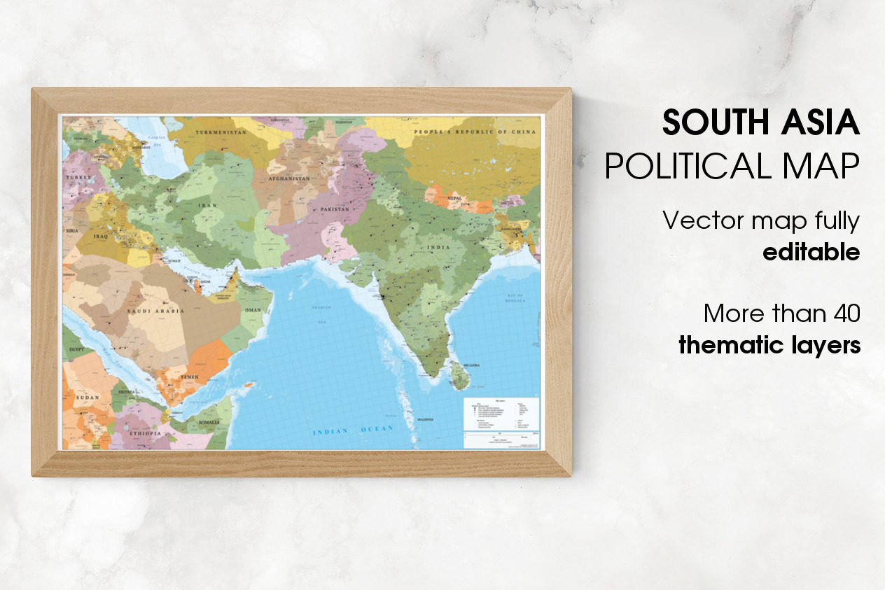
Map of South Asia and Near East
in Graphics / Illustrations
DOWNLOAD NOW Report
225
2
YOU MAY ALSO LIKE:


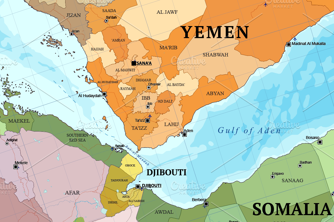
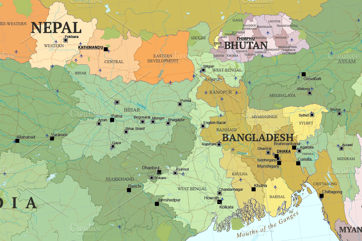
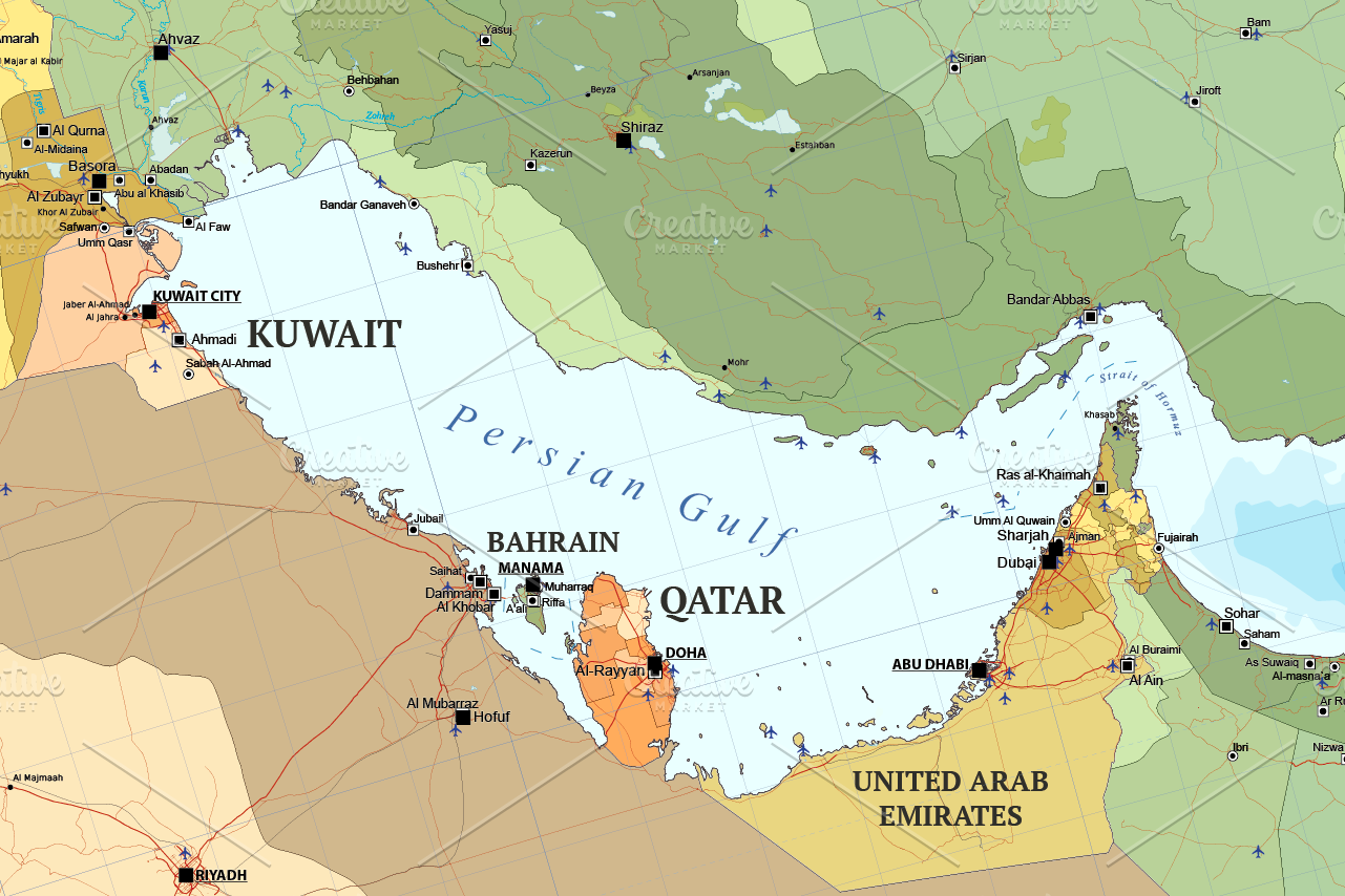
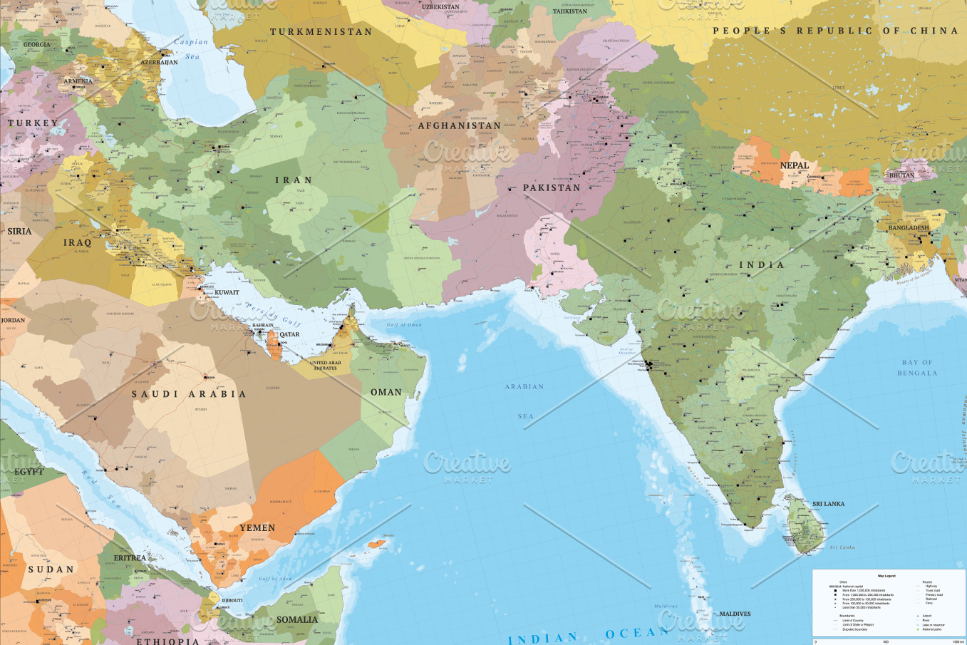
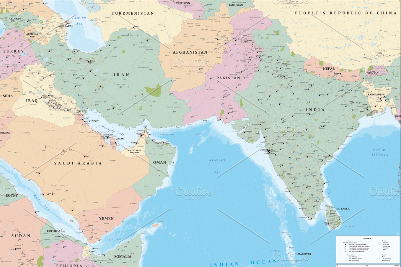
Large scale South Asia and Near East political map multi-layered in editable vector format. Highly detailed, ideal for illustrations, prints and multimedia projects. 100% editable including font text for ease of use.
Map with more than **1,000 cities, major roads, railways and sea routes**.
With **multiple thematic layers**:
- Coast lines and islands.
- Complete maritime routes.
- Countries (borders and fills in two styles).
- Countries names.
- Oceans and seas names.
- Depth contours.
- Rivers.
- Lakes and reservoirs.
- Geographic points names.
- Internal administrative boundaries (first-level administrative division).
- Internal administrative boundaries names.
- Capital cities.
- Major settlements (five levels layered by population).
- Motorways.
- Trunk roads.
- Primary roads.
- Railways of standard gauge.
- Airports.
- National Parks.
- Graticule with latitude/longitude.
- Map symbolization.
The design respect the rules and standards of cartographic composition with a style of colors and patterns consistent and creative. Adjacent polygons have not the same color, which helps the reader understand the map. All texts can be modified: real text, no outlines.
----
**Technical description**
- **More than 40 thematic layers**.
- **1,500 editable labels** with place names in real text.
- **Text:** Real text layered.
- **Languages:** English.
- **Projection:** Lamberts Conic.
- **Original scale:** 1:3,000,000
- **Dimensions:** 4A0 About (1682 x 2378 mm or 66.2 x 93.6 in). Scalable.
- **Formats:** Illustrator CS6 and Acrobat PDF.
- **Fonts:** PT Sans and Liberation fonts (included in the download).
----
**Notes**
- Suitable for use up to any size but if using the all layers of the map it is not suitable for under A4 due to the amount of detail.
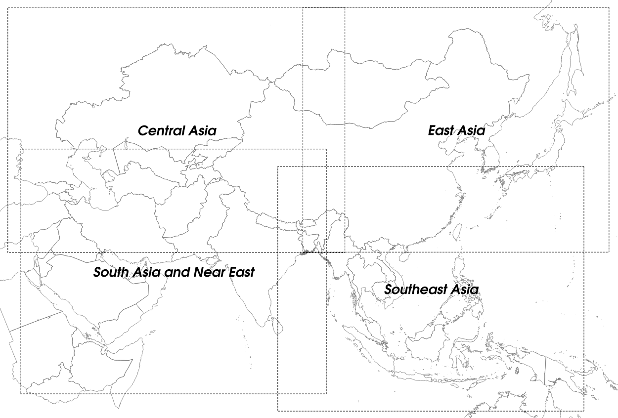
- See the image with the guide map to know the bounding box with the extension of this map.
- This map can be combined with: **Map of Asia - Central Asia** (https://creativemarket.com/egofer/2052896-Map-of-Asia-Central-Asia), **Map of Asia - East Asia** (https://creativemarket.com/egofer/2094078-Map-of-Asia-East-Asia) or **Map of Asia - South East Asia** (https://creativemarket.com/egofer/2138125-Map-of-Asia-South-East-Asia).
----
**Limited offer!**
With the purchase of this map you will be able to request a coupon for the **free download** of our **Abstract World Map Bundle**.
Map with more than **1,000 cities, major roads, railways and sea routes**.
With **multiple thematic layers**:
- Coast lines and islands.
- Complete maritime routes.
- Countries (borders and fills in two styles).
- Countries names.
- Oceans and seas names.
- Depth contours.
- Rivers.
- Lakes and reservoirs.
- Geographic points names.
- Internal administrative boundaries (first-level administrative division).
- Internal administrative boundaries names.
- Capital cities.
- Major settlements (five levels layered by population).
- Motorways.
- Trunk roads.
- Primary roads.
- Railways of standard gauge.
- Airports.
- National Parks.
- Graticule with latitude/longitude.
- Map symbolization.
The design respect the rules and standards of cartographic composition with a style of colors and patterns consistent and creative. Adjacent polygons have not the same color, which helps the reader understand the map. All texts can be modified: real text, no outlines.
----
**Technical description**
- **More than 40 thematic layers**.
- **1,500 editable labels** with place names in real text.
- **Text:** Real text layered.
- **Languages:** English.
- **Projection:** Lamberts Conic.
- **Original scale:** 1:3,000,000
- **Dimensions:** 4A0 About (1682 x 2378 mm or 66.2 x 93.6 in). Scalable.
- **Formats:** Illustrator CS6 and Acrobat PDF.
- **Fonts:** PT Sans and Liberation fonts (included in the download).
----
**Notes**
- Suitable for use up to any size but if using the all layers of the map it is not suitable for under A4 due to the amount of detail.
- See the image with the guide map to know the bounding box with the extension of this map.
- This map can be combined with: **Map of Asia - Central Asia** (https://creativemarket.com/egofer/2052896-Map-of-Asia-Central-Asia), **Map of Asia - East Asia** (https://creativemarket.com/egofer/2094078-Map-of-Asia-East-Asia) or **Map of Asia - South East Asia** (https://creativemarket.com/egofer/2138125-Map-of-Asia-South-East-Asia).
----
**Limited offer!**
With the purchase of this map you will be able to request a coupon for the **free download** of our **Abstract World Map Bundle**.
| File Type: | ZIP, PDF, AI |
| File Size: | 125.97 |
| Vector: | Yes |
| Dimensions: | 66.2 x 93.6 |
| Layered: | Yes |
| Compatible with: | Adobe Illustrator |